HISTORYOne of the things that distinguishes us from most other groups is that we emphasize the research aspect of the investigation. Yes, other groups do research, but all too often those groups repeat the same things they find on other paranormal sites, which in turn has been repeated before, without anyone fact checking. Do all groups do this? No, and perhaps it is wrong for me to say that 'most groups' do this; then again, I am taking a special kind of liberty in the fact that the word
research is in our name.
The reason why I bring this up isn't so that I can make ourselves look better. In this field of unknowns, we are all equal, we all have something to share, to learn, to teach. Fact of the matter is, the reason I bring up research is because I have been doing quite a bit of research on our next prospective site, this Riverside Cemetery. One of the items that came up was the historical setting, that of an Indian burial ground adjacent to the cemetery; this site has been marked as site 20-ME-1, and has been officially recognized by the National Register of Historic Places (as mentioned in the opening post). While delving through various websites and articles pertaining to that location, I finally came across just which Indian group this is identified with: the Red Ochre Culture.
There are a few sites on the internet that describe this culture, but in essence they all say the same thing.
- Quote :
- A unique culture called the Red Ocher Culture existed in the time between the end of the Archaic and the beginning of Woodland. This culture showed more social complexity than earlier people. The people were involved in long distance trade of exotic materials and practiced elaborate burial practices. A characteristic of this culture was its unique burial practices of using red ocher to decorate or cover the corpses of their dead. Red Ocher is ground up iron ore that is red in color.
Objects made from exotic materials were placed with the burials to mark the individual's status. Copper ornaments, marine shell beads and ceremonial blades (knives or points that were thinner and larger than could be practically used) have been found buried with some individuals. The trade networks and use of copper by the Red Ocher people have their beginnings in the trade and copper use of the Old Copper Culture. Red Ocher people used copper more to make ornaments (beads, rings) than tools, like the Old Copper Culture people did. Not all Archaic or Woodland people were involved in the Red Ocher Culture. This is a unique set of lifeways that only some people were involved in
-
Mississippi Valley Archaeology CenterCurrently, I am looking up burial rites and traditions of this group, and came across the attached document (yes, there's a document attached to this post!). The reason I am including it here is because the wait time to download the PDF, in addition to the questionnaire and log-in in requirement, was more than anyone should bear.
One of the things I've learned regarding this is that there may have been a mound in this area at one time. Apparently,
- Quote :
- The Red Ocher culture first appears during the Late Archaic. The Red Ochre culture is named after a pigment of ground hematite, or iron oxide. The bright red color is often associated with burial rituals of the Late Archaic culture. At this point archaeologists believed an intensification of burial rituals lead to the building of earthen mounds
-and-
- Quote :
- One phenomenon generally associated with Early Woodland is the construction of earthen mounds. A typical early Woodland mound would contain a shallow burial pit, extended burials, red ocher spread over the grave site and possibly some crude pottery and turnkey-tailed projectile points.
-
Effigy MoundsThis shouldn't be too surprising, as there are effigy mounds in this area. According to one site, Marinette County has had some mounds destroyed (see picture below) and we also have the Copper Culture Mounds in Oconto County. Granted, there is a couple thousand years separating the two cultures, so perhaps the tradition of mound building was lost... but it just strikes me as odd that the Red Ochre culture had a mound building tradition before (Copper Culture) and after (Woodland) their arrival, within the same geographical area, and they themselves did not extend that tradition?

(image taken from
Wisconsin Mounds)
Irregardless, we have a documented history of the area, something tangible that we can read up on, and perhaps shed some light to the paranormal sightings that have been reported. The downside to this is that, well, I really hope this doesn't fall onto the cliched "desecrated ancient Indian burial ground" bit (as if investigating a cemetery isn't cliched enough). I personally have a hard time trying to figure out why a cemetery would be haunted in the first place, especially since no one has died there. Then again, the reports are rather tempting, and with the history of the place, it just adds something.
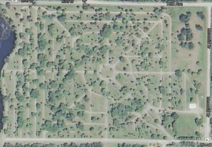
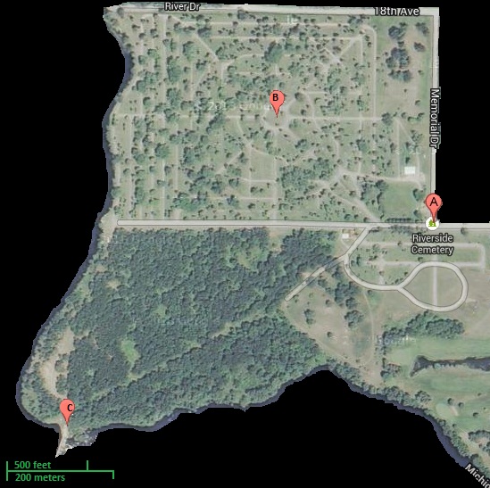
As mentioned above, I will be heading out there with one of our junior members to check things out. We'll be driving along the roads mentioned in the reports, trying to replicate the situation. We'll also go through the cemetery itself, try to see how things are situated, and then find out if we can get to the historical dig site.
{EDIT}
For some reason, I am unable to attach the document. I'm thinking it probably has some protection on it. No problem, I'll just cut and paste it here. Also, I have not included to reference section; it's too difficult to format an MFA on this forum. You can visit
Academia's page for the original document, complete with references, if you prefer.
...
Red Ocher Burial Variability: A Test of the Effect of Outsider Influence on the Conservation of Ritual Forms
Rob Ahlrichs
Abstract: Christopher Hays (2010) proposed that prehistoric ritual behavior is conservative by nature but can be changed by contact with outside groups. This hypothesis is tested using burial data from seven Red Ocher complex sites in Wisconsin. Red Ocher burials are uniquely situated to give an empirical measure of contact with outside groups, due to the inclusion of a relatively large number of non-local raw materials used for the manufacture of burial goods. The hypothesis test consists of comparing the number of different provenances of raw materials to the number of different burial contexts in each of three regions of Red Ocher burials. The resultant distribution of mortuary ritual variability is briefly discussed utilizing a core-periphery framework.
Key words: Red Ocher, ritual, mortuary, raw materials sourcing, Terminal Late Archaic
IntroductionIn a recent article about Adena mortuary ritual Christopher Hays (2010) laid the theoretical groundwork for a testable hypothesis in mortuary studies. He posits that ritual by its nature is both conservative and variable (Hays 2010:109), and that mortuary ritual, as expressed in the material remains of mortuary contexts would reflect this. It has been argued elsewhere that mortuary ritual is particularly susceptible to status motivated change in complex societies (Cannon 1989) often following the cyclical pattern of fashions or fads. However, Hays (2010:118) demonstrates that for the Adena, a relatively simple society, the amount of variability in the mortuary record depends more on interaction with extra-cultural influences than expression of status. Hays (2010:114) finds variability in three areas in Adena burials; type of interment, the distinctive collection of grave goods, and the level of stability through time especially regarding distribution of burials on the landscape. While it is certain that there are other factors, including environmental, social, and
 Figure 1. Map showing the location of all known Red
Ocher burials in Wisconsin.personal, that influence change in mortuary behavior, Hays’ (2010:109) hypothesis is that mortuary behavior will be more variable in societies that have a relatively higher number of cross-cultural interactions. Conversely, cultures with fewer cross-cultural interactions will have mortuary patterns that reflect conservation of ritual forms. The primary goal of this paper is to explore Hays’ model in a slightly different temporal and spatial setting in order to test its general applicability to the mortuary contexts of small-scale societies. This test will be conducted on data from Red Ocher complex burials found throughout eastern Wisconsin (Figure 1) where levels of extra-cultural contact can be measured through variable types and levels of exotic grave goods. The discussion will then employ the core-periphery model, as constituted by Jeske (2006) and introduced by Chase-Dunn and Hall (1991), to explain the pattern of variability found in the archaeological record.
Red Ocher, a term coined by Cole and Deuel (1937:61), like Adena, is known exclusively through burial contexts (Hays 2010:106; Pleger and Stoltman 2009). One Red Ocher complex site, located immediately adjacent to Wisconsin on the north bank of the Menominee River in Marinette, Michigan, has yielded good published radiocarbon dates which resulted in a time bracket for Red Ocher between 1000 B.C. and 400 B.C. (Pleger 1998:10). There are also two radiocarbon dates from the Southeast Wisconsin region (Jeske personal communication, 2011), though these are unavailable in the published literature. This time frame straddles the transition from the Late Archaic to the Early Woodland in Wisconsin, which represents a period of shifting subsistence strategies and the introduction of pottery (Stevenson et. al 1997:150). The geographical boundaries for these sites extend from the Upper Peninsula of Michigan south to central Illinois and west to east from Iowa to Ohio, with the highest concentration found in southeast Wisconsin (Ritzenthaler 1962:243).
It has been argued that the Red Ocher burials found across the upper Midwest do not constitute an archaeological culture (Jeske et al. 2010:48). It would perhaps be more appropriate to refer to the regional phenomenon as a distinctive burial assemblage given that all known Red Ocher sites are cemeteries and no settlements in Wisconsin have been associated with these burials. While this distinction does not help explain the relationship between the complex and the culture or cultures that participated in it, for coherence within this paper, and assuming that the people buried in Red Ocher cemeteries did live somewhere in the geographic territory bounded by these burials, the assemblage of traits described by Ritzenthaler and Quimby (1962) will be referred to as an archaeological complex.
MethodsHays (2010) utilized the Adena complex as a test case for his hypothesis. This archaeological culture is typified by mounds, which served as burials, and often included grave goods of finely crafted lithics caches, gorgets and distinctive effigy pipes (Woodward and McDonald 1986:11, 15). The Red Ocher complex, along with its contemporary mortuary manifestation to the east known as Glacial Kame (Cunningham 1948) are immediate temporal antecedents to the Adena (Ritzenthaler and Quimby 1962:244). Where the Adena mortuary system included burial in large, conical man-made mounds (Woodward and McDonald 1986:11), the Red Ocher/Glacial Kame complexes primarily located their burials in naturally occurring sand and gravel knolls (Pleger and Stoltman 2009:715). The earlier Red Ocher and Glacial Kame, like the Adena, also incorporated numerous grave goods including several varieties of finely worked exotic lithics caches, gorgets and many copper artifacts (Pleger and Stoltman
2009; Ritzenthaler and Quimby 1962). In order to profitably test Hays’ hypothesis, it is desirable to change as few variables in the data as possible. The only differences between Red Ocher and Adena mortuary complexes, aside from the obvious temporal difference, would appear to be Red Ocher burial in natural knolls as opposed to Adena burials in man-made mounds. Given these many similarities Red Ocher should serve as a functional comparative culture for testing the hypothesized correlation between outside contact and variability in archaeological mortuary contexts.
Red Ocher mortuary contexts are uniquely situated to produce a rough quantitative measure of contact with external groups. For this study, inclusion of different types of exotic goods in a burial is not a measure of variability, but of levels of outside contact. This is done in order to avoid using this category of data twice, once as a measure of contact and once as a measure of variability. Hays (2010:118) utilized other types of non-quantitative data, especially geographical setting and potential population movement based on that setting (e.g., broader river valleys support more people than narrow ones) to establish relative levels of interaction with extra-cultural influencers. These forms of analysis essentially do not apply to the much larger area under consideration in this paper and therefore the number of exotic goods will be used instead. This does not impact the hypothesis test which is attempting to establish that sites with relatively higher levels of interaction have higher variability in their burial contexts.
One of the diagnostic traits of Red Ocher burials is that they have very diverse grave goods (Ritzenthaler and Quimby 1962) with provenances from a range lesser than but comparable to that exhibited by Hopewell burial goods (Fitting 1978:45). One of the primary so- called nuclear traits of Red Ocher sites are caches of bifaces made of chert originating from the Ohio River in southern Indiana. This chert is called many names in the literature including hornstone or blue flint (Ritzenthaler and Quimby 1962:247) but is now known as Wyandotte Chert (Jeske et al. 2010:37). The presence of this lithic resource, from a very specific geographic location outside the boundaries of the Red Ocher complex, indicates some form of interaction with peoples from the Middle Ohio River Valley area, whether through direct contact, down the line trade, or some other mechanism. A second important lithic resource found in many Red Ocher burials are very long and thin chert biface blades most often made from Burlington or Burlington like chert (Pleger and Stoltman 2009:716), which is most readily available in the Mississippi and Illinois river valleys in western Illinois and southeast Iowa. The presence of this type of lithic material indicates some form of contact with social groups south and west of the Red Ocher cultural range. A third type of lithic artifact found in large caches are “trianguloid ovate blades” (Ritzenthaler and Quimby 1962:247). These are more commonly made from cherts found within the broader Red Ocher cultural range than the other types of caches. At some sites however, they are made from cherts not available in the immediate region (Hruska 1967; Pleger 1998:211), such as those found at the Riverside Cemetery site in Michigan’s Upper Peninsula, which were made from cherts mostly widely available in southwest Wisconsin. One exceptionally provenanced artifact at a Red Ocher site was a large core of obsidian from Obsidian Cliff in Yellowstone (Griffin 1969) found at the Riverside Cemetery site. Another important artifact class is shell beads, originating from either the Gulf Coast or nearby Atlantic coast (Pleger and Stoltman 2009:716). Also diagnostic at Red Ocher sites are copper artifacts, probably from the Upper Peninsula of Michigan and northern Wisconsin (Hill and Jeske 2011; Pleger and Stoltman 2009:716). Since this raw material is available throughout the area under consideration in this paper, it will not be included as a type of raw material indicating contact with outside groups.
The establishment of the degree of interaction with foreign societies, whose religious or ritual practices might impinge on the local society’s ritual conservatism, will be accomplished by identifying the number of different locations that grave goods have come from at each site. All provenance locations outside 100km (Taché 2008) will be considered exotic and be counted as contact with potential agents of change. This method leaves the question of the nature of that contact, undoubtedly an important variable whether it was through trade, raids, or exploration, out of the equation for the present in hopes of establishing a more robust theoretical model that will be able to incorporate this variable at a later time.
Most of these Red Ocher sites have been found accidentally, by landowners or construction workers in the course of mining or grading operations. This is at least partially influenced by the nature of the sites, namely that they are relatively deep burials in natural knolls, often with several inches to several feet of further sand deposition above the original pit surface. While the diagnostic artifacts can still be found in many collections around the state, the unfortunate consequences of these sites being found by non-archaeologists is that most of the burials have been highly disturbed by modern human rummaging before an adequate description of the position of the body and burial context can be recorded (Jeske et al. 2010). Of the 27 recorded and described Wisconsin Red Ocher sites (Overstreet 1980; Hruska 1967; Ritzenthaler and Quimby 1962) only seven had descriptions detailed enough to work within the current model. Despite this limitation I believe a fruitful test of Hays’ hypothesis can still be conducted by comparing regional variation through combining the data from several geographically related sites (Hays 2010:109).
I will contrast the variability in the mortuary programs of three regions within or near the state of Wisconsin. The first “region”, actually only one site due to the prolific number of burials pits (n=52), is the Riverside Cemetery, located on the north bank of the Menomonee River in the Upper Peninsula of Michigan. The second region will be called the southeast Wisconsin region and will be represented by three Red Ocher burial sites in Ozaukee, Jefferson, and Waukesha counties. The third region will be called the northeast region and is represented by three sites in Door and Manitowoc Counties. For each of the three sites or regions the number of identifiable extra-cultural interactions will be compared with the amount of variation in burial practices. There are several types of grave goods which will not be considered exotic, including copper, as it was available in the glacial till throughout the heart of the Red Ocher complex’s geographic extent (Hill and Jeske 2011), and some forms of Wisconsin cherts if there are outcrops of it within 100km of a site. Elements of the mortuary program that may be affected by variable levels of interaction with outside societies include the methods of interment and construction of the burial (Hays 2010:114).
Conservative features of the mortuary program for each of the three sites or regions include burial sites located on sand ridges or knolls, burial with some form of grave goods, though the specific form those goods take is widely variable from site to site and from burial to burial within sites, and inclusion of red ocher in the burial event (Hruska 1967; Overstreet 1980; Jeske et al. 2010; Ritzenthaler 1958; Brown
1924:70; Titus 1915:12; Brown 1913:62; Halsey 1972:1). The variation in grave goods will not be considered as part of the variation in burials because the relevant number of categories of these artifacts is currently unknown. For example, is a cache of 8 Wyandotte chert bifaces different from a cache of 11? Or, should we count individual Burlington chert bifaces or count them as a group? Study of the use of these artifacts is only beginning. An understanding of the artifact’s meaning, much less the meaning of the number of each artifact, in the ritual context is therefore beyond reasonable assertion. Moreover, if the artifacts were simply broken down into the reasonably
 Figure 2. This map shows the study areas to be considered in this paper.
meaningful and archaeologically/ethnographically supportable categories utilitarian and ceremonial, all three sites or region’s burial complexes would have both categories, and they could therefore be factored out of the analysis. Those portions of the burial behaviors recorded in the archaeological record that will be considered for the measure of variability in the burial program include the mode of interment (e.g. flexed, bundled or extended) and the type of burial enclosure (e.g. pit or structure). These categories have been demonstrated to be meaningful in this area and during this time period (Baerreis et al 1954:29; Overstreet 1980:71) and will help to address the larger question of variability in Red Ocher mortuary contexts (Hayden 1984:89).
InvestigationThe exotic grave goods at the Riverside Cemetery include obsidian, marine shell beads and gorgets, Knife River Flint, Wyandotte Chert, Burlington Chert and Prairie du Chein/Galena Cherts (Pleger 1998:224-233). This is a minimum number of six outside influences according to the model for this paper. The variation in methods of interments at Riverside is relatively high. Interments included secondary bundle burials (13), secondary cremation burials (11), primary flexed burials (14), extended primary burials (2), and in situ cremations (7) (Hruska 1967). Additionally these types of burials are interred in three distinguishable contexts including rounded pits (42), charnel house-type pole constructions (3), and stone covered burials (2) (Hruska 1967). The combination of these characteristics (e.g., bundle burial in a rounded pit or bundle burial in a pole constructed charnel house) represents a minimum of seven different interment methods utilized at the Riverside Cemetery site.
The southeast Wisconsin region is represented by the Convent Knoll site, the Jaco site, and the Thiensville site. The other ten Red Ocher associated sites identified by Overstreet (1980:76) from this area were so poorly documented upon discovery and subsequent investigation that the burial information is rendered useless to this investigation. There is also a Red Ocher affiliated site in northwest Sheboygan County, called the Theel Site, which would be ideal to add to either the northeast or southeast regions. The site contained a minimum of 19 individuals and had several different burial contexts. Unfortunately the lack of publically available publications on the site has prevented inclusion of this site in the current project. These three sites’ exotic burial goods include Wyandotte Chert (Jaco and Thiensville), shell (Convent Knoll and Thiensville), Burlington Chert (Convent Knoll) and Hixton Silicified Sandstone (Convent Knoll). These exotic items give a minimum number of four outside influences. The burial methods for this region included flexed (six for sure, and possibly two more from the Thiensville site), extended (3) and dismembered (one, though this may be more related to the death event than ritual). All three of these burial methods were found in pits so the minimum number of interment methods is three.
The east Wisconsin region is represented by the Hornstone site, the Michels Gravel Pit Burial site, and the Molash Creek site. These sites are relatively sparse, being represented by only one burial per site. The other Red Ocher sites in this part of the state are represented by solitary finds, interesting but incredible claims of giantism (Gerend 1920), and undocumented avocational excavations without sufficient documentation to get a picture of the burial setting (Ritzenthaler and Quimby 1962). The exotic goods found in these burials include Wyandotte chert (Hornstone and Molash Creek sites), shell (Michels Gravel Pit Burial site), and Burlington chert (Molash Creek site) (Brown 1924:70; Brown 1913:62; Halsey 1972:1) for a minimum number of three outside influences. The burial methods utilized at these sites include flexed and a possible bundle burial (Brown 1924:70; Titus 1915:12; Halsey 1972:1) for a minimum number of two interment types, though this region’s burial data is very scanty and would benefit from a much more robust sample.
Table 1. Summary of Red Ocher Burial Variation.
Regions or Sites.......... Number of Burials (utilized in this investigation)..........Number Exotic Goods Types..........Number of Interment TypesRiverside Site
..........................................47
.............................................6
........................................7
Southeast Wisconsin
..............................12
............................................4
........................................3
Eastern Wisconsin
...................................3
.............................................3
........................................2
DiscussionIt must first be acknowledged that the number of interment types in the table above (Table 1) could easily be most affected by the number of burials at a site, rather than the number interactions with foreign ideologies. This possibility can only be tested with more data concerning the Red Ocher burial complex. As has been lamented many times, the records of burial excavations and opportunity to research Wisconsin’s burials have not been of professional grade, throughout its history of archaeological investigation (Jeske 2010:22; Overstreet 1980:87; Halsey 1972:2). It will be up to future researchers to methodically test the level of variability in Red Ocher sites if they ever become available for analysis.
This study essentially confirms the conclusions drawn by Hays (2010:118). For the Red
Ocher burial cult those sites that show a greater number of contacts with outside groups also have a more variable mortuary program. Based on Hays’ conclusions it can be tentatively stated that the Riverside Cemetery community was larger and more connected with the world outside the borders of the Red Ocher cultural territory than either the northeast Wisconsin region or the southeast Wisconsin region. This then begs the question of how and why did Riverside become a center of the Red Ocher complex given its relatively isolated location? Both the northeast and southeast Wisconsin Red Ocher regions are physically closer to the areas where exotic Red Ocher burial goods originate than is the Riverside Cemetery site. This circumstance limits the applicability of a down-the-line trade model of exchange.
Utilizing the core-periphery model (Chase-Dunn and Hall 1991:19), the heavily used Riverside Cemetery area could be interpreted as a core, with the other more southerly regions being peripheral groups. The Red Ocher complex in Wisconsin fits this model in two ways. First the level of complexity between Riverside and the other sites has been shown to be very different, with the Riverside site exhibiting a higher level of complexity. Second the Riverside site has economic precedence over the other Red Ocher regions, as demonstrated by the inclusion of a greater number of types of exotic raw materials despite being geographically farther removed from those materials (Chase-Dunn and Hall 1991:19). It is possible that this relationship developed from the population that used the Riverside Site utilizing their geographic advantage over the acquisition of copper (Jeske 2006:286), which was widely distributed throughout the Midwest and especially in Red Ocher burials (Ritzenthaler and Quimby 1962). Copper or some other as-yet archaeologically invisible class of objects such as perishable food items could have driven the trade from the Riverside site point of view. The lack of settlement data associated with burial sites for this time period is the primary obstacle to determining the nature of this trade.
The Riverside Cemetery area could have served as a hub for the smaller settlements nearby in the northeast region of Wisconsin. The variety of the artifactual evidence fits this model. Riverside Cemetery has both a greater number of burials and greater variety of grave good provenance within those burials than do the outlying communities in the surrounding counties. If down-the-line trade or diffusion were responsible, there would be a gradual decline in the incidence of a material from the point of origin. For example, obsidian and Knife River Flint were both found only at the Riverside Cemetery even though there are many other Red Ocher sites along the river systems between the Riverside Cemetery and the Wyoming and North Dakota sources of these materials.
If the Riverside Cemetery acted as a hub of trade in the north for the northeast and eastern Wisconsin regions, it is possible that there was a similar hub in the south, since the southeast Wisconsin region seems to be the most highly concentrated region for the Red Ocher burial cult (Ritzenthaler and Quimby 1962; Overstreet 1980). It is also possible that this site has already been destroyed or that the region represents a separate society, utilizing the same or a similar burial ritual (Hays 2010:118) but a different more egalitarian form of social interaction.
ConclusionThis investigation of the Red Ocher burial cult in Wisconsin, with some qualifications, has demonstrated that Red Ocher burial practices were likely influenced by outside sources during interaction with other societies. It has also failed to falsify the hypothesis, with those same qualifications, that higher levels of interaction led to greater variability in the mortuary setting. The Riverside Cemetery site, which had at least six different outside influences, also had the highest variability of burial practices with seven different scenarios. The southeast Wisconsin and east Wisconsin regions each had lower numbers of interactions evidenced, four and three respectively, and also had lower variability in burial practice, three and two respectively. The geographic fact that Riverside Cemetery is the most distant of the three regions from any of the sources of the exotic resources leads to the utilization of the core- periphery model as an explanatory framework, with Riverside being a core, due to its relatively high level of usage and exotic goods.
This study has not revealed the type of interaction occurring between individual Red Ocher groups or between Red Ocher groups and other outside groups other than perhaps suggesting a core-periphery model for the northern region. Finally, these models would be greatly enhanced by the discovery and scientific excavation of new Red Ocher burial sites and from excavation and description of any settlement sites that could be linked to Red Ocher burials.